 HISTORICAL SOCIETY
of HARFORD COUNTY, Inc.
HISTORICAL SOCIETY
of HARFORD COUNTY, Inc.
PHOTOGRAPHS OF
HAVRE DE GRACE - NORTH
Susquehanna and Tidewater Canal, Pivot Bridge,
and The Susquehanna
Museum of Havre de Grace
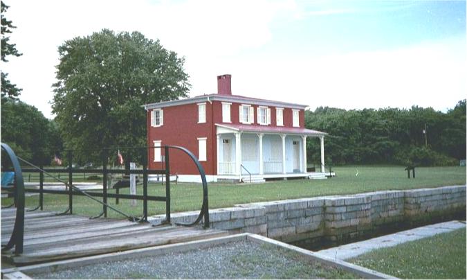
The Lock House (1840) was used as an office to
collect tolls for boats headed upstream and to house the locktender and his family.
Since the river was not navigable north of the Lock House, the canal ran 45 miles to
Wrightsville, Pennsylvania. The oulet to the river is directly in front of the Lock House.
Photographed in 2001
Tow Path of
Susquehanna and Tidewater Canal at Havre de Grace
The Canal Basin, Ice Houses,
and Old Pennsylvania Railroad Bridge are also shown.
James T. Wollon Collection,
Photographer and date photographed are not known.
The Former Philadelphia, Wilmington, and Baltimore Railroad Bridge
and the Old Railroad Ferry Landing on the Perryville Shore of the Susquehanna Bridge.
The above photograph is the late 19th century photo used to illustrate the cover
of the Spring 2002 issue of the Harford Historical Bulletin, "Six Susquehanna Bridge Crossings:
Thirteen Bridges"
From the Archives of the Historical Society of Harford County
Major General
Marquis de LaFayette
This Statue is located where the Old Post Road (1665) met the
Susquehanna Lower Ferry (1695). Many
notables, LaFayette, George Washington, and armys used the Old Post Road to travel
north and south.
Photographed in January 2006.
Map of Historic Sites in Havre de Grace
Return to Harford County Photographs
RETURN TO HISTORICAL SOCIETY
OF HARFORD COUNTY
|